
 Multi Function Displays
 Radars
 Fish Finders & Transducers
 GPS & Chart Plotters
 Autopilots
 Navigation
 Sonars
 Commercial
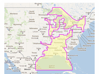
MM3-VNA-023
MSRP: $263.00
C-Map Wide Chart - Gulf of Mexico, Great Lakes & Rivers. Vector charts & standard resolution satellite photos for part of the Great Lakes.
Chart RegionsUSA Central or USA
Chart TypeVector or Satellite Photo or C-Map
Prices and Specifications Subject to Change Without Notice.
All prices shown are in USD. Prices are valid in US and Canada only.
C-Map Wide Chart - Gulf of Mexico, Great Lakes & Rivers. Vector charts & standard resolution satellite photos for part of the Great Lakes.
This Chart Pack includes vector charts for Gulf of Mexico, Great Lakes, and Rivers, plus standard resolution satellite photography for part of the Great Lakes. C-Map chart data is used and converted to the TimeZero format.
These C-MAP charts are comprised of the same cartographic chart information found in C-MAP MAX and C-MAP MAX PRO charts.
Note that you will need to purchase an unlock code to view this chart data. Unlock Codes for NavNet 3D systems may be purchased from your Authorized Furuno Dealer or Authorized C-MAP Dealer. .
To purchase this chart pack for NavNet, you will need to provide your NavNet system ID to your local authorized Furuno dealer. The system ID can be located under the “My NavNet” menu on your NavNet system.
Upgrade to the latest version for 50% of the chart purchase price.